Sharm El Sheikh – History & Tours
Sharm El Sheikh is a coastal city located at the southern tip of the Sinai Peninsula, where the Gulf of Aqaba meets the Gulf of Suez. Its geographic position has given it historical, strategic, and environmental significance long before it became a modern tourist destination.
In ancient times, the area around Sharm El Sheikh was known primarily for its natural harbors and proximity to important maritime routes connecting Africa, Arabia, and the Levant. Although no large ancient cities were established in the area due to its arid environment and lack of freshwater sources, the surrounding seas were navigated by traders and sailors moving through the Red Sea.
During medieval periods, the Sinai Peninsula served as a land bridge between continents and a route for pilgrims and merchants traveling between Egypt and the Arabian Peninsula. The waters near Sharm El Sheikh remained important for navigation, fishing, and regional trade, even though the settlement itself remained small and undeveloped.
In the 20th century, Sharm El Sheikh gained strategic importance due to its location overlooking the Straits of Tiran. This position made it a focal point in regional geopolitics and maritime control. Over time, the area transitioned from a sparsely populated coastal outpost into a planned city.
The transformation of Sharm El Sheikh into a modern city began in the late 20th century, when development plans emphasized environmental protection and sustainable growth. The surrounding coral reefs, desert landscapes, and marine ecosystems were recognized as valuable natural assets, leading to the establishment of nearby protected areas such as Ras Mohammed National Park.
Today, Sharm El Sheikh represents a unique blend of natural history and modern development. Its story reflects how geography, sea routes, and environmental awareness shaped a city that connects ancient maritime pathways with contemporary global tourism, while maintaining a strong focus on conservation and ecological balance.
Ras Mohammed National Park
Ras Mohammed National Park is Egypt’s first national park and one of the most significant natural reserves in the region. It is located at the southern tip of the Sinai Peninsula, where the Gulf of Aqaba meets the Gulf of Suez. This unique geographical position has played a major role in shaping the park’s natural environment over millions of years.
The landscape of Ras Mohammed was formed through a combination of tectonic movements, volcanic activity, and gradual changes in sea levels. These geological processes created dramatic coastal cliffs, underwater coral walls, salt marshes, and desert plains. As a result, the area became home to one of the richest marine ecosystems in the Red Sea.
Long before it was protected, Ras Mohammed remained largely untouched due to its remote location. Marine scientists later discovered that the area hosts hundreds of coral species and an extraordinary diversity of marine life, including reef fish, sea turtles, rays, and migratory birds. The strong water currents in the surrounding seas help maintain healthy coral growth by continuously bringing nutrients from deeper waters.
In 1983, the Egyptian government officially declared Ras Mohammed a national park in order to protect its fragile ecosystems from overfishing, pollution, and uncontrolled tourism. This decision marked a turning point in environmental conservation in Egypt and established Ras Mohammed as a model for sustainable tourism in the region.
The park is also known for several natural landmarks that reflect its geological and ecological history. White Island is a natural sandbank that appears and disappears depending on tides and sea conditions. Magic Lake is a shallow saltwater lagoon famous for its changing colors caused by sunlight and mineral content. The Earthquake Crack is a visible reminder of the tectonic forces that shaped the Sinai Peninsula.
Today, Ras Mohammed National Park stands as a living natural museum, representing the delicate balance between desert and sea. It remains a symbol of Egypt’s commitment to preserving its natural heritage and continues to be recognized internationally as one of the most important protected marine areas in the world.
White Island Sharm El Sheikh
White Island is a unique natural phenomenon located in the Red Sea near Ras Mohammed National Park, south of Sharm El Sheikh. Unlike traditional islands, White Island is not a permanent landmass. It is a natural sandbank formed by the meeting of sea currents and tidal movements in this part of the Red Sea.
The island’s history is closely connected to the geological and marine processes that shaped the Sinai coastline over thousands of years. Strong currents flowing from the Gulf of Aqaba and the Gulf of Suez continuously deposit fine white sand and coral fragments in this shallow area. Over time, these deposits created a bright sandbank that appears above the water during calm sea conditions and low tide.
White Island gained its name from the striking white color of its sand, which contrasts sharply with the surrounding turquoise waters. The sand is composed mainly of crushed coral and marine sediments, giving it its soft texture and reflective color under sunlight. Because the island is shallow and exposed to changing tides, it may partially or completely disappear during high tide or rough sea conditions.
Historically, White Island remained largely unknown and untouched, as it has no permanent structures and cannot support vegetation. Its location within the protected boundaries of Ras Mohammed National Park helped preserve its natural state. When Ras Mohammed was declared a national park in 1983, White Island became part of a protected marine ecosystem governed by strict environmental regulations.
The surrounding waters of White Island are rich in marine life, supported by nearby coral reefs and shallow lagoons. These ecosystems play an important role in maintaining biodiversity in the Red Sea and serve as breeding and feeding grounds for various marine species.
Today, White Island is recognized as a rare example of a temporary natural formation shaped entirely by sea dynamics. Its changing appearance serves as a reminder of the constant interaction between land and sea in the Red Sea region. The island remains an important symbol of the fragile balance of marine environments and the importance of conservation in protected areas like Ras Mohammed National Park.
Tiran Island Sharm El Sheikh
Tiran Island is a strategically and environmentally significant island located at the entrance of the Straits of Tiran, where the Gulf of Aqaba meets the Red Sea. Its position has made it important both historically and geographically, serving for centuries as a natural gateway controlling maritime access to the northern Red Sea.
Geologically, Tiran Island is part of a chain of islands formed through tectonic activity associated with the Red Sea rift system. Over time, coral reefs developed extensively around the island, creating some of the richest marine habitats in the region. These reefs grew along steep underwater walls shaped by shifting plates and changing sea levels, resulting in dramatic drop-offs and strong currents.
Historically, the Straits of Tiran have played a crucial role in regional navigation and trade. Control of these waters influenced access to ports along the Gulf of Aqaba, including ancient trade centers that connected Arabia, the Levant, and Africa. Tiran Island’s location made it a natural reference point for sailors navigating these narrow passages.
In the modern era, Tiran Island gained international attention due to its strategic importance in the mid-20th century, when control of the Straits of Tiran became a key factor in regional geopolitical events. Despite these tensions, the island itself remained largely undeveloped, preserving its natural landscape and surrounding reefs.
Environmentally, Tiran Island is renowned for its exceptional coral ecosystems. The strong currents flowing through the straits continuously bring nutrient-rich water, supporting vibrant coral growth and a wide diversity of marine life. This natural process has allowed the reefs around Tiran Island to remain among the healthiest in the northern Red Sea.
Today, Tiran Island is recognized primarily for its ecological and historical value rather than human settlement. It stands as a symbol of the close relationship between geography, history, and the sea, representing how natural formations can influence navigation, trade, and regional history while maintaining their pristine character over time.
Hurghada
Hurghada is a coastal city located along the western shore of the Red Sea in Egypt. For most of its history, the area remained a small and remote settlement shaped primarily by the sea, desert environment, and traditional maritime activities.
Historically, Hurghada began as a modest fishing village in the early 20th century. Local inhabitants relied mainly on fishing, pearl diving, and small-scale maritime trade along the Red Sea coast. Due to the harsh desert climate and limited freshwater sources, the settlement remained small and largely isolated for decades.
The Red Sea waters surrounding Hurghada have long been known for their rich marine life and extensive coral reefs. These natural features developed over thousands of years through geological processes related to the Red Sea rift system. Coral growth, combined with stable sea conditions, created one of the most diverse marine ecosystems in the region.
Hurghada’s transformation began in the latter half of the 20th century, when the area’s natural coastline and underwater environments attracted attention for recreational and scientific purposes. Gradual infrastructure development connected the city to other parts of Egypt, allowing Hurghada to expand beyond its original fishing roots.
As the city grew, awareness increased regarding the ecological importance of its surrounding marine environments. Nearby islands and reef systems were recognized as valuable natural habitats, leading to conservation efforts and the establishment of protected marine zones. These measures helped preserve coral reefs and coastal ecosystems despite growing human activity.
Today, Hurghada stands as an example of how a small coastal settlement evolved into a modern city while remaining closely connected to the natural history of the Red Sea. Its story reflects the relationship between human development, marine ecosystems, and the importance of environmental awareness along Egypt’s eastern coastline.
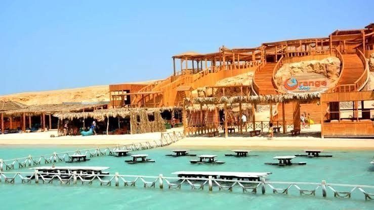
Orang Bay Island ( Giftun Islands )
Orange Bay Island is a natural beach area located within the Giftun Islands group, off the coast of Hurghada in the Red Sea. Its history is rooted in the geological and environmental evolution of the Red Sea rather than in ancient human settlement or monumental construction.
The Giftun Islands were formed through tectonic activity linked to the Red Sea rift system, followed by thousands of years of coral growth and sediment accumulation. Orange Bay itself developed as a shallow sandy bay where fine coral sand was deposited by gentle sea currents, creating calm turquoise waters and a soft shoreline.
For centuries, the waters surrounding Orange Bay were used mainly by local fishermen and passing sailors. The island’s lack of freshwater sources and its protected reef environment prevented permanent habitation, allowing the area to remain largely untouched by human activity for most of its history.
The ecological significance of Orange Bay lies in its surrounding coral reefs and seagrass meadows. These ecosystems support a wide variety of marine life and play an essential role in maintaining the health of the Red Sea. The shallow lagoons act as natural nurseries for fish and other marine species, contributing to the region’s biodiversity.
As Hurghada developed into an international seaside destination in the late 20th century, Orange Bay became known for its natural beauty and tranquil setting. Environmental protection measures were introduced as part of broader conservation efforts around the Giftun Islands to reduce damage to coral reefs and coastal habitats.
Today, Orange Bay Island represents the delicate balance between natural marine environments and responsible human access. Its history reflects the geological forces that shaped the Red Sea coast and the growing awareness of the importance of preserving fragile island ecosystems for future generations.